Property Record
4950 Riverton Dr, Dayton, OH 45414


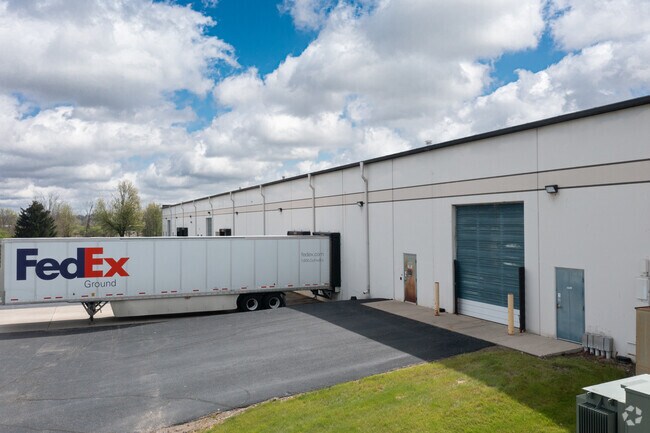
Property Detail
4950 Riverton Dr
Dayton, OH
LOT 82287 SHOUP MILL FARMS SEC 3
R72117416-0001
MONTGOMERY
Warehouse
Ohio
AE The base floodplain where base flood elevations are provided. AE Zones are now used on new format FIRMs instead of A1-A30 Zones.
82287
2024
4.58 AC
2025
North Dayton
080500
Cincinnati/Dayton
44,500 SF
NEARBY LISTINGS FOR SALE OR LEASE
DEMOGRAPHICS near 4950 Riverton Dr
1 mile
3 mile
5 mile
2025 Total Population
6,852
61,481
164,716
2030 Population
6,831
62,551
167,799
Pop Growth 2025-2030
(0.31%)
+ 1.74%
+ 1.87%
Average Age
37
40
40
2025 Total Households
3,162
26,981
72,090
HH Growth 2025-2030
(0.09%)
+ 1.63%
+ 1.86%
Median Household Inc
$44,579
$47,026
$49,020
Avg Household Size
2.10
2.20
2.20
2025 Avg HH Vehicles
1.00
1.00
2.00
Median Home Value
$125,867
$103,207
$128,153
Median Year Built
1959
1957
1959
Nearby Places
Map Layers
Map Styles
 Street
 Aerial
Layers
 Traffic
 Biking
Places
Listings with unknown addresses are not visible on the map
- Restaurants
- Banks
- Shops
- Fitness
- Groceries
PUBLIC TRANSPORTATION
AIRPORT
James M Cox Dayton International
Drive
Walk
Distance
James M Cox Dayton International
17 min
8.7 mi
Freight Ports
Port of Toledo
Drive
Walk
Distance
Port of Toledo
173 min
150.1 mi
SALE & LEASE HISTORY
LISTING DATE
SALE/LEASE

Sep 24, 2016
For Sale
Dec 06, 2019
For Lease
Nearby Properties
Address
Land Use
TOTAL SIZE
Lot Size
Zoning
Address
Land Use
TOTAL SIZE
Lot Size
Zoning
104,192 SF
923.52 AC
Address
Land Use
TOTAL SIZE
Lot Size
Zoning
22,133 SF
47.58 AC
Address
Land Use
TOTAL SIZE
Lot Size
Zoning
678,154 SF
1,128.84 AC
Address
Land Use
TOTAL SIZE
Lot Size
Zoning
5.92 AC
Address
Land Use
TOTAL SIZE
Lot Size
Zoning
144,340 SF
91.38 AC
Address
Land Use
TOTAL SIZE
Lot Size
Zoning
20.16 AC
Address
Land Use
TOTAL SIZE
Lot Size
Zoning
170,977 SF
8.65 AC
Address
Land Use
TOTAL SIZE
Lot Size
Zoning
100,716 SF
4.31 AC
Address
Land Use
TOTAL SIZE
Lot Size
Zoning
505,736 SF
45.42 AC
Address
Land Use
TOTAL SIZE
Lot Size
Zoning
313,421 SF
19.55 AC
Address
Land Use
TOTAL SIZE
Lot Size
Zoning
634,508 SF
24.36 AC
Address
Land Use
TOTAL SIZE
Lot Size
Zoning
99,601 SF
15.58 AC
Address
Land Use
TOTAL SIZE
Lot Size
Zoning
183,333 SF
5.12 AC
Address
Land Use
TOTAL SIZE
Lot Size
Zoning
220,548 SF
23.11 AC
Address
Land Use
TOTAL SIZE
Lot Size
Zoning
106,375 SF
2.26 AC
Address
Land Use
TOTAL SIZE
Lot Size
Zoning
509,060 SF
31.03 AC
Address
Land Use
TOTAL SIZE
Lot Size
Zoning
12,924 SF
51.34 AC
Address
Land Use
TOTAL SIZE
Lot Size
Zoning
6.25 AC
Address
Land Use
TOTAL SIZE
Lot Size
Zoning
239,750 SF
9.12 AC
Address
Land Use
TOTAL SIZE
Lot Size
Zoning
94,671 SF
6.42 AC
Address
Land Use
TOTAL SIZE
Lot Size
Zoning
93,360 SF
694.57 AC
Address
Land Use
TOTAL SIZE
Lot Size
Zoning
1,189,046 SF
45.07 AC
Address
Land Use
TOTAL SIZE
Lot Size
Zoning
23.29 AC
Address
Land Use
TOTAL SIZE
Lot Size
Zoning
6.57 AC
Address
Land Use
TOTAL SIZE
Lot Size
Zoning
101,698 SF
19.06 AC
Address
Land Use
TOTAL SIZE
Lot Size
Zoning
193,311 SF
9.37 AC
Address
Land Use
TOTAL SIZE
Lot Size
Zoning
92,615 SF
2.68 AC
Address
Land Use
TOTAL SIZE
Lot Size
Zoning
162,286 SF
15.25 AC
Address
Land Use
TOTAL SIZE
Lot Size
Zoning
243,256 SF
13.58 AC
Address
Land Use
TOTAL SIZE
Lot Size
Zoning
46,592 SF
5.32 AC
The World's #1 Commercial Real Estate Marketplace
Connect with us
© 2026 CoStar Group
The information above has been obtained from sources believed reliable. While we do not doubt its accuracy we have not verified it and make no guarantee, warranty or representation about it. It is your responsibility to independently confirm its accuracy and completeness. Any projections, opinions, assumptions, or estimates used are for example only and do not represent the current or future performance of the property. The value of this transaction to you depends on tax and other factors which should be evaluated by your tax, financial, and legal advisors. You and your advisors should conduct a careful, independent investigation of the property to determine to your satisfaction the suitability of the property for your needs.